Monday, June 29, 2015

June 7, 2015 - North Cascades National Park, WA to Davenport, WA

Oh my my! It was very bright outside even though our Lil Home (LH) was nestled inside the woods.  We cannot complain because we knew it meant a great day for sightseeing and photography.  Since there were no hookups at the campground we had to turn on the hot water heater using propane, so we can take a bath.

A simple and quick, but delicious breakfast was prepared: Ground beef mixed with hash browns, chopped sausage and bacon.

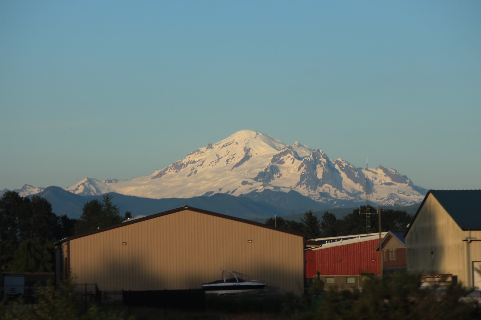
We checked out of the campground at 9:55 am, turned right onto State Route (SR) 20 to go to Spokane, WA.  Along the way there were eye popping views of the mountains.  At every chance we could, we would pull over to the pullouts to catch a good view of the mountains.


There were more viewpoints up ahead and again there was another beautiful view of the mountains.  The roads were twisty, but beautiful and thrilling.

A deer almost tried to run across the road as we were approaching, but apparently it was startled and headed back.

We went through the western themed town called Winthrop, WA, but the place was too crowded for us to find an ample parking spot because today is Sunday.  Nah, we are not going to go 'round and 'round looking for a spot and we can always come here another time.

After leaving Winthrop we continued on SR 20 East to Twisp, WA.  While in Twisp, WA we turned right to SR 153. The view along the route was really beautiful.

"Hey, try to stay away from guard rails and barriers", Edith yelled at Erwin.  There were times Edith thought Erwin was driving too close and that scared Edith several times. Erwin's reply was "plenty of room and I was not even that close to barriers". :-)

In Pateros, WA we made a left turn to get on 97 North to Brewster, WA, then made a right turn to 173 South to meet Bridgeport, WA.  We crossed the bridge over Columbia River.

Coming to Bridgeport there were lots of farmlands and orchards.  Many small houses were lined up in a row for transients.

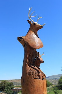
In Bridgetown, WA there was many carved trees lined up Foster Creek Ave.


Next stop was at Grand Coulee Dam where we went to the visitor center.  Once inside we were then informed that the dam tour started at 3 pm and we were there around 2:45 pm.  The tour is about a mile plus away.  We asked if it was possible to drive the LH over there.  "No problem", the tour guide said. However, we had to make nature call and knew that we may not be able to make it on time for the 3 pm tour. We hurriedly drove to the dam tour site, but missed the tour by few minutes.  They had a tour at 4 pm and they told us we could sit down and wait.  We decided not to and went back to Grand Coulee town to do grocery shopping at Safeway.


It was steamy hot when we left the grocery store. Once inside the LH we checked the external temperature and it was 104˚.

Now approaching the town of Wilbur, WA where we turned left to get on highway 2 for Spokane, WA.

Pretty Koi mural on the side of pizza restaurant in Wilbur town when we went by it.


In Creston, WA we swung by the Tiny Chapel. It is not as tiny as others we have seen.  There is a cowboy on a horse statue next to it. As the sign mentioned it is a chapel for anyone who wants to stop, rest and pray.


From there we continued driving on 2, then decided to cut short the trip and pulled into a vacant lot just outside of Davenport, WA. There are several national park campgrounds north of Davenport, but it is more than 18 miles to go there and we were already too tired to continue.

For supper we had seared rib eye steak and steamed broccoli/cauliflower/carrots. Even though we dry camped we used the generator to run air conditioning for a little while, so our bedroom will feel cool when we turned in for the night.

Miles driven:
LH - 223
Jeep - 0

Today's route:
A: North Cascades, WA
B: Bridgeport, WA
C: Grand Coulee & Coulee Dam
D: Creston, WA
E: Davenport, WA

Saturday, June 27, 2015

June 6, 2015 - Bellingham, WA to North Cascades, WA

It was indeed a very beautiful morning. The sun was out and it was 64˚. 

Erwin was the first one out of the bed, got things readied for our trip to North Cascades National Park. Edith was lazyboned, but Erwin made her get out and get going. Erwin has to have his coffee, so he prepared a pot of it.  Few motorhomes and other RVs were already gone. There was a cargo van parked in front of us few feet away and they were deaf.  No, we did not go to them and say hi to them.  

We were getting low on cash, so we stopped, on our way back to I-5, at Bank of America.  

From I-5 Exit 232 we are now on Cook Road going to meet SR 20 in Sedro Wooley, WA


The drive on SR 20 was very lovely and captivating.  We stopped at North Cascades Parkway Visitor Center to look around, take a hike and to ask questions about campground.  


After getting information from the ranger we went outside and took a short stroll to Sterling Munro Viewpoint (330 ' boardwalk trail).


Inside the Visitor's Center at North Cascades
On way to Sterling Munro Viewpoint 
The Picket Range


Newhalem Creek Campground is near the visitor center and it has two loops, and we wanted to see what Loop 'A' sites are like. We liked site #5 and it was vacant.  We parked the Lil' Home on it, drove the Jeep to kiosk to register. One night fee is $16, but for Seniors over 62 years old or those having Eagle Pass card pay only $8 a night.  We did not have small change on us, so we put in $10. 

After getting the LH leveled up and slideouts out we went back to State Route 20 going East to check out several overlooks/viewpoints. The first stop was Gorge Creek Falls trailhead.  We hiked about 1/3 of a mile, saw a couple small waterfalls.


Next stop was to go to North Cascades Environmental Learning Center. The parking lot was really really full, but we managed to find one tight spot that the Jeep could fit into. If we had driven our LH we won't be able to park it anywhere.  Anyway, there were lots of bathers there and the view was gorgeous!


Diablo Dam, we drove on the bridge to the other side, checked out campground. Not suitable for our LH, too small spaces and uneven terrain.


Then to Diablo Lake Overlook and the wind was very overpowering.  You can see all trees leaning in one direction because of the mountain winds. Since those trees are exposed they are sculpted into whichever way the wind blows.  It was a good thing that today was a lovely day.  


Wind sculpted trees
Next one was Ross Lake Overlooks, but after we parked and walked a bit we decided not to continue and drove away.


We did not see fires, but it may have been put out before we got there

We had enough to see for the afternoon and were on our way back to the campground.  Since we were in a national park there is no grocery store and we needed to get few breakfast items.  The nearest store was like 35 miles away, so we stopped at Shell Gas stayion in Marblemount to pick up eggs and milk.

Leaving Marblemount, WA Edith took over driving because Erwin started to feel tired and sleepy.  


After supper we played a new game we bought last week.  It is Tri-ominos (3 sided domino). Erwin won the first game.  


Since it was cool and pleasant we went out for a short walk around the campground. There were no hookups at all sites it got little warm in our bedroom, so we opened the window by each side of the bed.  Nice gentle breeze came in.


Around 11:45 pm Edith got up to check out the stars and the Milky Way, but the sky was not pitch black yet. She went back to bed disappointed.


Miles driven:
LH - 87
Jeep- 120

Today's route:
A: Bellingham WA
B: I-5 Exit 232
C: Sedro-Wooley, WA
D: North Cascades Nehalem Creek Campground, WA


Thursday, June 25, 2015

June 5, 2015 - Anacortes, WA TO Bellingham, WA

Note: This is Wayne Sinclair's version of our trip.  Edith asked him to make notes of what we did and he graciously offered to tell his side of the story allowing us to take a break from writing this.
"Edith, you can take a day off from writing your Meandering Notes as I’m happy to oblige for Friday, June 5, the day you and Erwin came up to Bellingham for our rendezvous."

Here goes:

It was a beautiful morning and it would have been a perfect day for boating with Cathy and her husband Bobby, but we had another plan to go meet our dear friend, Wayne Sinclair in Bellingham, WA.

Camping at Fidalgo Bay RV Park
We left Fidalgo Bay RV Resort at 9 am, got fuel at Swinomish Casino/Gas. $2.89 for diesel. While there Edith texted Wayne to make arrangements on where to meet in Bellingham. We could see Glacier Peaks (10,365') and Mount Baker (10,700') while on way to I-5 after leaving the gas station.

View of Mount Baker on our way to I-5 from Fidalgo Bay 
We got on I-5 North from Route 20. While enroute we saw 2 deer grazing on the median!  Then there was one deer running alongisde I-5. 

We took Exit 256 (Meridia Ave), arrived at the parking lot of Walmart at the northern end of Bellingham, Washington at 10:20 am.  When we left Anacortes early this morning it was 56˚, but it has rose to 66˚ by the time we got to Bellingham. Bellingham is the county seat of Whatcom County, the last county before the Canadian border.  The parking lot is surprisingly small for the Walmart standards but we managed to secure a space for our Lil' Home and the jeepy Jeep that loyally follows us around.  

Soon after we secured our Walmart space, our friend, Wayne Sinclair, of Surrey, British Columbia, Canada, arrived in his tiny blue Toyota Prius. We performed the usual rites of greetings and then showed him our new home. “Awesome,” “Wow,” and “Fantastic” were amongst his reactions.  Erwin proudly showed off his famed wood burning work.  Before getting ready to head out with Wayne Edith collected several pieces of her photographic equipment to take to Wayne’s car.

After securing the home-on-wheels on the busy parking lot, we entered Wayne’s minuscule automobile with no coaches, no bathroom, no bed, no refrigeration — yeah, not even a cooler. Still, Wayne was kind enough to show us around the northwest part of the Northwest state of Washington. We went south through Bellingham, and after two or three detours that we encountered, managed to reach the south end of the town.  It is the oldest part of Bellingham, and is called Fairhaven Historic District.

Wayne parked close to the locally famous historical plagues he wanted to show us.  We walked a short distance and saw the first plague.  This one was on the site where the Chinese settlers were not allowed to cross into the city and also revealed that the mayor made an apology very recently (2011). 


Another one marked the site where dogs were to be drowned, yes, the drowning pool for the dogs. 


One more showed the place where Mathew was cut in two by a streetcar. There was a garbage dump, and the accompanying plague stated it smelled like an elephant’s breath.  (How did they know?)


In addition to Edith's pictures, you can see more at www.fairhaven.com/historical/category/C100

Even palm trees are grown in Washington state!


Then we returned to the historic district itself, and walked around to look for a restaurant.  Wayne explained to Erwin and me that he had other out-of-town visitors (from Ohio) wanting to sample the local cuisine in the historic district.  He obliged and took the Ohio people to a Mexican restaurant.  The visitors objected, saying this was “not what we wanted.”  

Being a Canadian that Wayne was (he is a proud dual citizen), he explained that Mexican food was one of the most popular cuisines in the U.S. “There are almost no Mexican restaurants in Canada,” he explained.


After this little story,  Edith decided to eat in a Mexican restaurant! “I love Mexican dishes."  So we went into the very-out-of-place-in-Fairhaven-Historical-District Mexican restaurant staffed by people very well versed in the art of Mexican cooking.  


Jalapeños Mexican Grill was indeed a delight for all three people sitting outside on a patio upstairs.  The food was great! However, it was not the only reason why it was a delight.  We did not have to pay for Wayne’s fare.

The waitress dropped Wayne’s dish accidentally, and the plate smashed into smithereens with enchiladas and tacos, refried beans, and salad scattered over a chair, part of our table, and the patio. Eventually, another attempt at serving him was successful. The bill for our lunch did not include Wayne’s lunch.  Lucky us! Edith forgot to take pictures of the dishes we all ordered!

After lunch, we wandered about and visited an art gallery showing paintings of totem poles, boats, the sea, and the mountains around the northwest corner of the state. There were several other interesting places but we did not have much time so we returned to Wayne’s 11-year-old car, powered by the still original battery. He knocked on his head.

Watch your hands, Edith!


We got on Interstate 5 and went north.  As we left Bellingham, our heads turned to the right. We found Mt. Baker covered in clouds.  Not very picturesque, Edith thought, so she did not use her camera to catch the state's third highest mountain.  Wayne mentioned that it was the second most active volcano in the contiguous United States after Mt. St. Helens.  

We still travelled further north, with fewer and still fewer miles left in the United States as we approached Canada.  Erwin panicked a little bit, saying, “We don’t have our passports with us.” 

“Not to worry,” Wayne said, as he exited I-5 at Exit 276. the very last exit of the United States of America.  Then we proceeded to the parking lot of Peace Arch State Park, beyond which was a row of average looking houses. “These houses you see are in Canada,” he announced. No fence separating the two countries.  Open space. As they were part of Metro Vancouver, he explained the houses cost over a million dollars each, a huge contrast to the similar but $200,000 houses in the border town of Blaine, Washington, a block or two south!


Houses in Canada - a stone's throw from US/Canada border line
Then Wayne parked his car at a space where we were allowed 15 minutes to roam about.  We rushed to the Peace Arch, built in 1914 to commemorate the 100 years of peace between the United States and Canada. (It was a nasty and silly little war when the British and Canadians burned the White House in 1813 in revenge for the Americans’ burning down Canada’s Parliament Buildings in 1811.) 


 See the difference in the colors of asphalt dividing two countries
Erwin setting one foot on Canada and the other on US
Wayne is in the background


Wayne was very mindful about Erwin’s recent FB post suggesting closing the borders. So he teasingly pointed at “May these Gates Never Be Closed” inside the Peace Arch!  Here is a picture of Erwin and Wayne pointing at these words.


Erwin & Wayne

After walking around briefly at the two parks, yes, two parks, meaning Peace Arch State Park and Peace Arch Provincial Park, and having set our feet on the Canadian grass (Finish touch Canada!), we returned to the car.


We went to Marine Drive in Blaine where we stopped to see White Rock, B.C., across Semiahmoo Bay from us.  It was quite a contrast to the rural setting of the northwest corner of the state; White Rock with a few high-rising condo buildings looked crowded just for being part of the huge metropolitan area.  Then we walked about the marine park and discovered several killer whales and salmon.  Edith took pictures of them.  


Wayne then took us to Semiahmoo Resort as he wanted to show us several laid-down totem poles beside an abandoned boat.  Upon our arrival there, we found no totem poles present, much to Wayne’s dismay! There were the boat and a weathered building so Edith took pictures of them.  She was fascinated by an attention-capturing water tower to she took several pictures of it.  


Then we went to Birch Bay, a popular destination of the locals, meaning those from Seattle and Vancouver, B.C.  There was an attractive campground, and we considered getting a site for our home that evening. We decided against it as it was a lot more feasible to keep our home by the Walmart store.  

We had our lemonade drinks at Shores Restaurant & Bar in Birch Bay, and waited for Wayne’s affectionate and bubbly partner, Janice, coming to us from her work in Vancouver, B.C.


Finally, the four of us entered a restaurant at the beach front. We were seated by a window facing Birch Bay, part of Pacific Ocean.  Several Canadian islands were at the sea’s horizon. The sun was descending from its peak of the day, thus making the quiet sea shining. All of a sudden there was an interruption to the sea quietness. There were splashes caused by a black figure that gave an appearance of a seal.  It was swimming quickly toward a stick. We found soon enough that the animal had four legs. It was a black dog!

Still the view was awesome.  Just a little over two months ago we left our home in Florida next to Atlantic Ocean. We drove diagnocially across the United States from the southeast to the very extreme northwest. With the shining sea just below the sun approaching the horizon, we had travelled From Sea to Shining Sea. 

Via Birch Bay CafĂ© & Bistro was a fascinating place to eat; the seafood dishes were at the top.  The salmon was very deliciously flanky.  We consumed everything and became too full for the dessert except Janice. She was the only one who did not have a seafood dish; she had chicken. So she helped herself to an upside down pineapple cake, while we looked at her savouring it.  We did not mind it as Wayne paid for our dinner, smile. Unfortunately for him, there were no accidents.


After dinner, we four had our last-minute chats. Then Janice left to go out of the country into Canada, about ten or fifteen minutes away.  We rode in Wayne’s car to return south to Bellingham.

Good Times, Good Cheer, Good Friends

On the way back, Mt. Baker made very surprisingly prominent its appearance with no clouds blocking the view.  Edith could not help it but took countless pictures of the white majesty, an awesome commanding presence. At over 10,000 feet high, its appearance was startling as we were just above the sea level. The difference between where we were and the peak of the mountain was indeed impressive, so impressive that she could not help but felt paralyzed taking pictures of the mountain uncontrollably. Awesome!


We owe our appreciation to Wayne for showing us around the area.  He was understandable about our reluctance to enter Canada as we had not completed our paperwork for the new home but we do look forward to his and Janice’s showing us around their Canadian southwest corner and across southern British Columbia.

Good night y'all. Resting comfortably at Bellingham Walmart


Written by Wayne

WAYNE'S DISCLAIMER: Because of this iPhone, sometimes words get changed or autocorrected and go through to you in spite of my watchful but 20th-century-generated eyes with assistance from my 21st century eyeglasses. So if the contents don't make sense, don't blame me; blame this Geek's toy. Thank you. 

Miles driven:
LH - 45
Jeep - 0

Today's route:
A: Fidalgo Bay RV Park
B: Bellingham
C: Fairhaven District
D: Peace Arch Park - US/Canada Border
E: Blaine, WA
F: Birch Bay, WA
G: Bellingham Walmart